
Introduction
Environmental waters of eastern and southern Sumatra, Java Sea, Karimata Strait, and the Sunda Strait has changed extremely since the formation of Sunda Shelf during the last Ice Age (Hanebuth et al., 2000; Voris, 2000), and Bird et al. (2005) conducted a detailed study of ancient environment in the region. However, the effect of the formation of the Java Sea or the waters between Java and Sumatra and Borneo to the monsoon system in the region is not really understood yet. For these reasons, the reconstruction of the ancient environment is very important, particularly through the study of ancient climates and environments. This study will focus on understanding the evolution of environmental change inferred from seismic reflection data and using drill core of surface sediments seafloor derived from the Jakarta Bay (TJ-17) that is already available through several expeditions of Marine Geological Institute-ESDM. The seafloor of Java Sea region is tectonically stable since the Late Pleistocene. An intensive study of the role of El Niño / Southern Oscillation (ENSO) and climate system in Indonesian monsoon variations over the time scale ranges from the last 1000 years, approximately the Holocene until the end of the Ice Age will obtain the dynamics of the environment changes, with or without human interference. To be able to estimate the modern climate variations, it is necessary to understanding the dynamics of climate change from time to time so that the necessary understanding of variations in past climate change by reconstructing the ecological changes in the past.
Study Area, Objective and Method
This short paper is part of the report activity 2013 of the SiNas Program under Kemenristek program that focus on the environmental change aspects due to natural or anthropogenic effect inferred from seismic reflection and sea surface sediment core of the Jakarta Bay. The data was conducted in 2010 during MGI –ESDM survey (Zuraida et al., 2010). Figure 1 shows the location of the reflection seismic activity in the Bay of Jakarta and Coring location of TJ-17 while Figure 2 is a cross-sectional analysis of the location and seismic reflection elected.
This study aims to improve understanding of the influence of human behavior and its impact on the environment from the point of view the climate change every time. This knowledge will be useful in planning future development and management of the coastal environment. The Jakarta Bay represents a region that can better reflect environmental changes due to climate-related natural and human activities such as industrialization, agricultural or otherwise. For the analysis, it is assumed wave velocity in sedimentary rocks (soft) of 2000 m / s or every 25 m / s correlate to thickness or depth of 6.25 m. Figure 3 is a seismic reflection cross section and analyses.
The TJ-17 core of Foraminifera observations and analyses carried out on drill core sediment at intervals of 5 cm to a depth of 50 cm and then 10 cm intervals at depths below 50 cm. The analysis shows fluctuations plankton content of foraminifera in sediments as indicator of environmental change.
Literature Review
The Earth climate variation experienced was well documented in the sedimentary rocks that were deposited on the surface of the seafloor. In the Indian Ocean region, climate or temperature changes or variations have been recorded since the Early Miocene (21.8 to 17.6 million years ago (Ma) or Late Oligocene (25 Ma) is characterized by warmer sea surface temperatures are constantly up to Middle Miocene or 13-14 Ma (Srinivasan and Chaturverdi, 1990). Maximum warmer temperatures were followed by temperate in Middle Miocene in the tropics regions due to ice caps melting in Antarctica to set up temperate temperatures around tropical Indian Ocean region (Srinivasan and Chaturverdi, 1990). In the Middle Miocene (11-12 Ma), important changes were possible by disconnecting of the equatorial of Indian Ocean region with Pacific Ocean region (Kennett et al., 1985). Environmental changes or variations in climate (temperature) at the time strongly influenced by tectonics activities such as formation of outer-arc and volcanic-arc or land up lifted of the Java or Sumatra region or Antarctic ice caps melting. At the end of the Miocene (6.2 Ma), global cooling occurs and followed by sea level drop (regression) that might be associated the occurrence of global climate change and tectonic events or land up lifting. A temperature variability continues as recorded in Early Pliocene (5.2 Ma) and Late Pliocene (1.8 Ma), that are characterized by cooling sea surface temperatures. Sea surface temperature decreases continuously during the Pleistocene cause spread out of tempera temperatures due in the tropical region. The data suggest, in the past, a climate variations and environmental changes over controlled by natural events such as tectonic activity that causes an increase or decrease in relative sea level. Later, volcano activity also can cause the Earth's temperature and the relative increase can be followed by melting polar ice caps.
In the modern era, climate or temperature variations are characterized by increased in sea surface temperatures (SSTs) as recorded in the Timor region (Cahyarini, al,, 2009). Meanwhile, in the Siberut and Mentawai Islands, a sea surface temperature was increased about 3.2 ºC over a period of 11 years in the 14th century (Cahyarini, SY, 2010). Extreme environmental changes supposedly followed the climate change or climate variations in the Southeast Asia caused by sea level rise to 120 m at the optimum the last Ice Age about 20-17 thousand years ago (Voris, 2000). The Sunda and Sahul Shelf had been sinking and separated the island of Sumatra, Kalimantan and Java and also Papua and Australia (Voris, 2000). This transgression event, in consequently was decreased rivers gradient and causes decreased rate of sedimentation.
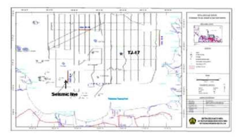
Figure 1. Seismic line and core sample (TJ-17) location
Since the end of the ice age, Sundaland area environment changes drastically. Human activities such as mining, farming, logging or industrialization has led to the mountainous
region along the island of Sumatra, Java and Kalimantan to be open and experience the intense erosion due to the wet season with high rainfall.
Result and Discussion
Result
Results
In this paper present seismic reflection cross section interpretation (Figure 2), 2 km long, north-south in direction and 6 m depth, located approximately 9 km to the north of modern Ciliwung River (Figure 2). Total thickness of seismic reflection cross section about 49-50 m.
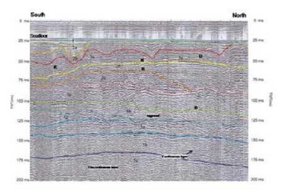
Figure 2. Interpretation of seismic reflection in northern modern Ciliwung River, Jakarta Bay
The seismic cross section shows development of the northern coastal area of Jakarta Bay. The left side is mainland (south), while the open sea (north) or modern offshore area at right side. There is no indication of the fault activity for the whole seismic image that indicate no tectonic activity had done or the study area is tectonically stable condition.
The seismic reflection can be identified about 5 unit rock layers. The older layer is 5c layer at depth of 42.5 to 45 m from the sea floor that is characterized by rough or strong reflector. On the south side, sediment layer was dominated a relatively discontinuous layer or short sigmoidal which interpreted as terrestrial sediments (fluvial) or transition, while to the north is characterized by a continuous layer that interpreted as shallow marine environment (Fig. 2, layer 5c). Other continuous, fine and steep -angle of sigmoidal layers estimated deposits in the delta environment.
The layer 5b, about 6.25 m thick illustrates more extensive continuous layer indicate gradually transition (5c to 5a) into the marine environment (Onlap) until the middle section. While, on the south side, the rough surface erosion may characterizes a terrestrial or fluvial environment. Depositional environments ranging from delta to shallow marine at the north side of the cross-sectional developed 5a layer that is characterized by coarse continuous layer about 4.25 to 5.75 m thick. The formation of layer 5a was dominated by moderate to coarse grained sediment under strong energy deposition. Sediment deposition is continuous form layer 4c, 1.25 to 3.75 m thick with wedge shape. The bottom of 4b layer is characterized by surface erosion, which indicates important in environmental conditions changes. Wedge shape of the layer itself indicates the occurrence of fast marine regression to lead an environmental change by terrestrial or fluvial followed by erosion processes and formation of canals. The 4b layer, 1.25 to 3.75 m thick is discontinuous layer, a sigmoidal shape and canals characterize terrestrial environments with minimal sediment supply. The terrestrial environmental conditions continually to 4a Layer on the south side and it was characterized by a continuous layer and canals shape are interpreted as fluvial environment deposition (river sediment) and coastal or shallow marine environments and also delta formation that is characterized by a steep angle sigmoidal form on the north side indicate marine environment with low energy and minimal sediment supply. The 4a layer thickness varies from 2.5 m in the south up to 7.5 m on the north side. Fluvial environmental conditions uninterrupted toward younger 3c layers, with thickness varying from 1.25 to 3.75 m that is characterized by a discontinuous layer, channels forms or nicks. The important events of transgression recorded in 3b layer. It is characterized by a continuous bedding cover or eroded the 3c layer to form wedge shape and offlap at the bottom layer transform into Onlap at the top bedding at the northern section. Continuous bedding is characteristic of 3b layers and it was interpreted as marine sediments with a thickness of 6.5 m and generally thinning toward the south section about 1.25 m. A coral growth (reef or R, in Figure 2) observed as bending layer forms. Marine environment constantly develops until the bottom of the 3a layer accompanied by coral growth (R), and delta formation (D) in the northern part of the section that is characterized by large-angle of sigmoidal layer, continuous coral growth (R) and a shallow marine environment in the south side of the cross section. The 3a layer thickness is remaining varies between 2-3 m due to strong erosion formed a deep valleys and wide V or U-shaped valley with a relative depth about 2 to 4 m. These valleys are part of river valley (fluvial) in the south section and become a valley in a shallow marine environment in the middle and on the north side of section to form the 2b layer with a thickness varies about 2.5 m to 5 m. These events possibly associated with the addition of high density of sediment volume or very strong energy of sedimentation so that to form valleys or submarine channels and eroded the 3a layer. Deposition in terrestrial environments is continuous in the southern section (Layer 2b) but in the middle and northern section filled by shallow marine sediment deposits and canals (2b) and corals growth (R) in transition region. The 2b layer has a thickness ranging from 2.5 m to 5 m thick. On the north side section, marine environment deposition is continuous while at the south side was dominated by rivers or shallow marine environment sedimentation with a thickness about 1.75 to 3.25 m (2a layer) and continuation of coral growth. The youngest bedding is fine and soft sediments of shallow marine environment indicate relatively low energy sedimentation with a thickness of 80 cm to 1.5 m (1 layer).
Coring Analyses
The shallow sediment coring data (TJ-17; Figure 1), 100 cm to 160 cm length, indicates significant anthropogenic influences. The main elements are utilized in this study include silicon (Si), titanium (Ti), iron (Fe), and calcium (Ca). The Si and Ca element content shows uniformity pattern up to a depth of 155 cm-135 cm. Ca content increases ranging from a depth of 135 cm to a depth of 100 cm while the Si content fluctuates. Ca content
decreased rapidly to a depth of 50 cm while Si decreases slowly. The content of Si and Ca decreased significantly starting from a depth of 50 cm to the surface of the drill core.
Metal content of Titanium (Ti), iron (Fe) and copper (Cu) in drill core vary greatly decreased for Ti and Fe but increase content of Cu from a depth of 150 cm and a slight increase in the depth of 105 cm for Ti. Ti and Fe elements content decreased rapidly from a depth of 50 cm, while Cu is slowly rising. Cu rapidly ascending at a depth of 20 cm while the Ti and Fe decreased strongly at a depth of 25 cm followed later by an increase Ti and Fe near the surface.
The heavy metals content in the bottom of the drill core is sourced from nature like as from PbS (galena), PbCO3 (cerusite) and PbSO4 (anglesite) minerals, while a heavy metals content on the surface most likely comes from human activities such as industry or industrial waste, and agricultural fertilizer. The content of Pb, Zn and Cr (also Cu) have the same pattern in nature is likely due to a massive sulfide minerals group such as Cu- Pb-Zn are often found in volcanic areas. Chrome or chromium, Cr is often found in volcanic rocks as chromium oxide FeCr2O4, while Sn, tin is present in nature as the mineral cassiterite or tin oxide SnO2.
Even, the heavy mineral of Cadmium, Cd and tin, Sn has a content varies pattern but they tend to decrease. Start from 60 cm depth, the Cd and Sn content increased strongly at a depth of 50 cm and then declined precipitously. Near the surface, the Sn content increased sharply followed by Cd might be associated with industrial and agricultural activities.
The Foraminifera observations carried out on sediment core at intervals of 5 cm to a depth of 50 cm and then 10 cm intervals at depths below 50 cm. The analysis shows fluctuations plankton content of foraminifera in sediments.
Foraminifer plankton is common present in the open seas, so, fluctuation of the presence of foraminifer plankton in sediment could be indicated a change in ocean circulation. In addition, there were also fluctuations in the content of benthic foraminifer with porcelain shells that are generally owned by benthic foraminifer of the Miliolina ordo commonly found in high salinity. This probably reflects a change in salinity at the study site as observed at a depth of 25 cm. Content fluctuations were also seen in the presence of Asterorotalia that can indicate the current strength of a region. Although fluctuations Asterorotalia seen in this example, but a comparison of the average grain size is nearly uniformly silt sized indicates that the current changes are not large enough to prevent the deposition of silt in the sediment. The sharply increase content of Ammonia at a depth of 20 cm showed a decrease in environmental quality causes a decrease in the number of species other than Ammonia. Increased environmental degradation is observed clearly from a depth of 20 cm where Ammonia sp sharp increase followed by a decrease Porcelain and comparison of plankton presence (P / B).
Discussion
The seismic reflection analysis of Jakarta Bay has been able to identify some of the environmental changes related to sea-level rise events or transgression, sea level drop or regression, due to reduced or increased sediment supply related to climate change (weather) or environmental degradation (Figure 3). The oldest layer (5c) in the seismic
section estimated as the Cisubuh Formation, the Early Pleistocene age (Technical Report not published, 2010) which is deposited in terrestial and coastal environment.
Sea level rise event occurs in older bedding (5b-5a and 4c). Continuous bedding and coarse sediments of 5a layer were interpreted as sedimentation of medium-coarse grained material due to strong energy associated with the wet season. A transgression events uninterrupted until the south section (4c layer) as shown in Figure 2).
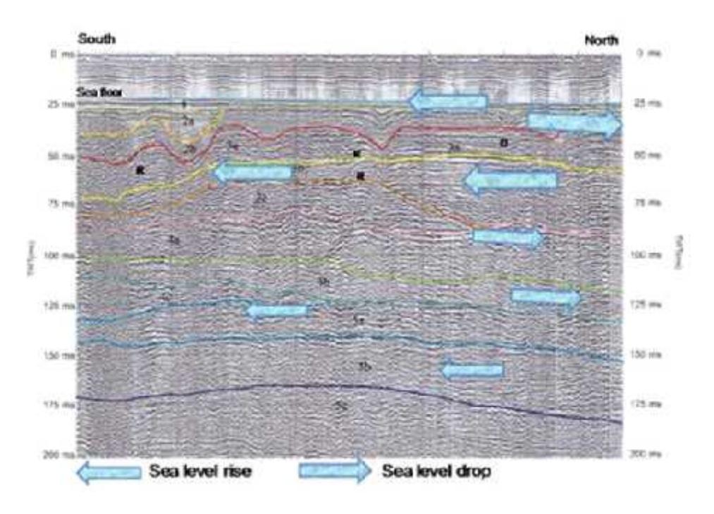
Figure 3. Environmental changes events interpreted from seismic reflection.
Sea level drop events was followed by depositional environment changes of 4b Layer as terrestrial environment on the south side that eroded the bottom of 4c layer and delta environment (D) or shallow marine on the north side. The sea level drop events constantly to form the 4a layer in terrestrial or fluvial environments especially on the south side and the delta or a shallow marine environment in the north side. Canals or valley development (Ancient River?) within sediment filling indicates significant sediment supply in 4a Layer. This fact can be interpreted the strong erosion events on terrestrial region could be related to important wet season brings quite a lot of erosion materials. The 4a Layer developed at the north (right side) in transition, delta or shallow marine. A terrestrial environment conditions extended to 3c Layer is characterized by surface erosion as a respond to continuation of sea level drop event. Environmental conditions change drastically as a result of the sea level rise/transgression events that develop 3b bedding that erode some of the 3c layers. The 3b bedding start form shallow marine environment, delta or coastal environments on the north side which gradually change into the marine environment. Coral (R) at base of 3c layer (Thousand Islands?) grown in the transition condition at the north side region. A continuous sea level rise is forming 3a layer that is characterized by coastal environment on the south side and coral growth at the middle of section and delta (D) on the north side. Environmental conditions change rapidly due to sea level drop events that erode portion of the layer 3a surface. The 3a layer was covered by 2b Layer that deposit in terrestrial environment such as fluvial environment (rivers) within deep and wide valley. Strong erosion due to possible sedimentation energy or high density sediment material to form a wide and deep valley that might be associated with an intense wet season conditions. Sea level event gradually occur on the northern side of seismic section while at the south section remained terrestrial environments deposition to form Layer 2a that eroded 2b layer. The sea level gradually cover the entire of Jakarta Bay area that are characterized by continuous deposition of fine material of coastal and shallow marine environments to form the 1 layer.
Ups and downs of Si and Ca content might be associated with the sediments content deposited by rivers and are not associated with the fluctuations discharge or current due to relatively constant of grain size. When it were associated with sediment sources, the Si and Ca associated with volcanic deposit where the headwaters Bekasi River or Cigombong River. The Si and Ca contained in a feldspar mineral as volcanic products. The Si content decline start from 50 cm depth indicates a decrease or cessation of volcanic activity as a source of sediment. The Gede Pangrango volcano is active in the Quaternary period with 21 eruptions since 1747 until then less active since 1957 (Iguchi et al., www.dpri.kyoto-u.ac.jp/~kazan/13k02/iguchi.pdf). Moreover, the increase content of Cu, Ti and Fe near the surface is most likely associated with industrial activities or other human activities began to be detected at a depth of 50 cm. Such as Si and Ca, Ti and Fe content decreases sharply at a depth of 50 cm associated with a decrease in sediment source of volcanic material.
The Pb, Cr, and Zn have relatively stable content with pattern rose toward the surface. The content of Zn slightly increased at a depth of 50 cm and Pb, Cr, and Zn content start increased constantly at depth of 20 cm. Increased content of heavy metals in surface most likely related to human activities such as industry, transport and agriculture, while heavy metal content at the bottom layer is derived from volcanic rocks erosion or directly related to volcanic activity. The industrial and agricultural activities was indicated by the Sn content increased sharply followed by Cd near the surface. Increased environmental degradation is observed clearly from a depth of 20 cm where Ammonia sp sharp increase followed by a decrease Porcelain and comparison of plankton presence (P / B).
Concluding Remarks
Seismic reflection analysis of Jakarta Bay has resulted in an understanding of the changes in the environmental conditions recorded in sedimentary rocks of the Jakarta Bay. Least 3 times the event of sea level rise and sea level drop events 2 times were happened in the past. Wet or dry season indication interpreted of rough or smooth layering form associated with sedimentation energy. Least 3 times of the wet season identified brings relative rough material or 3 times event of dry season that bring fine materials with minimal energy. The sea level drop event was followed by the formation of deep and wide valleys that can be interpreted as a result of the high energy sedimentation accompanied with high density material such as laharik flow or large and intense rainfall. The environment degradation well recorded in the sediment surface cause mostly from human activity.