
1. Weaknesses on the Utilization of Marine Resources in Indonesia
Based on preliminary identification of problems in marine resources utilization in Indonesia, there are some fundamental weaknesses in the way how the country utilizes its marine resources. The weaknesses have become major inhibiting factors of marine resources utilization in Indonesia.
1. Marine Boundaries Problems
Under the Constitution of the Republic of Indonesia 1945 Section 18 (1), the Unitary Republic of Indonesia is divided into regional provinces which are then divided into districts and the city with their own local government legislation reserved. Article 25 states that the Republic of Indonesia is an archipelago nation that characterized the region and the boundaries and rights stipulated by law. Those two article above confirms that each province, district and city have the rights and their limits that should be set by the law. For the determination of the boundaries of the area provided in Law No.2 1999 amended by Law No. 32 2004 amended by Law 232014 about Regional Government, and Regulation of the Ministry of Home Affairs No. 1 2006 amended by No.76 2012 about Guidelines for Confirmation of Regional Boundaries. For the determination of the rights provided in Law No.27 2007 amended by Law No.1 2014 about the Management of Coastal Areas and Small Islands.
The enactment of the Law Number 32 year 2004 which was later amended by the Law Number 23 year 2014 about Local Government had provided greater autonomy to local government which has some implications to marine and ocean boundaries management. Unfortunately, not all the implications are constructive. The central government authorizes the local authority is not limited to purely administrative affairs but also in terms of resource utilization and its wealth management including marine resources. This confirms that the Indonesian marine are managed by a local government that has marine boundary authority to manage marine resources in the most distant 12 nautical miles (for provinces) measured from the shoreline toward open sea and/or the direction of the archipelagic waters, and 1/3 (one third) of the jurisdiction of the provinces for districts/cities. Implementation of this law has yet to be realized by each province and county/city located in coastal and marine Indonesia due to limited human resources and inadequate financial resources to conduct marine boundary determination and affirmation.
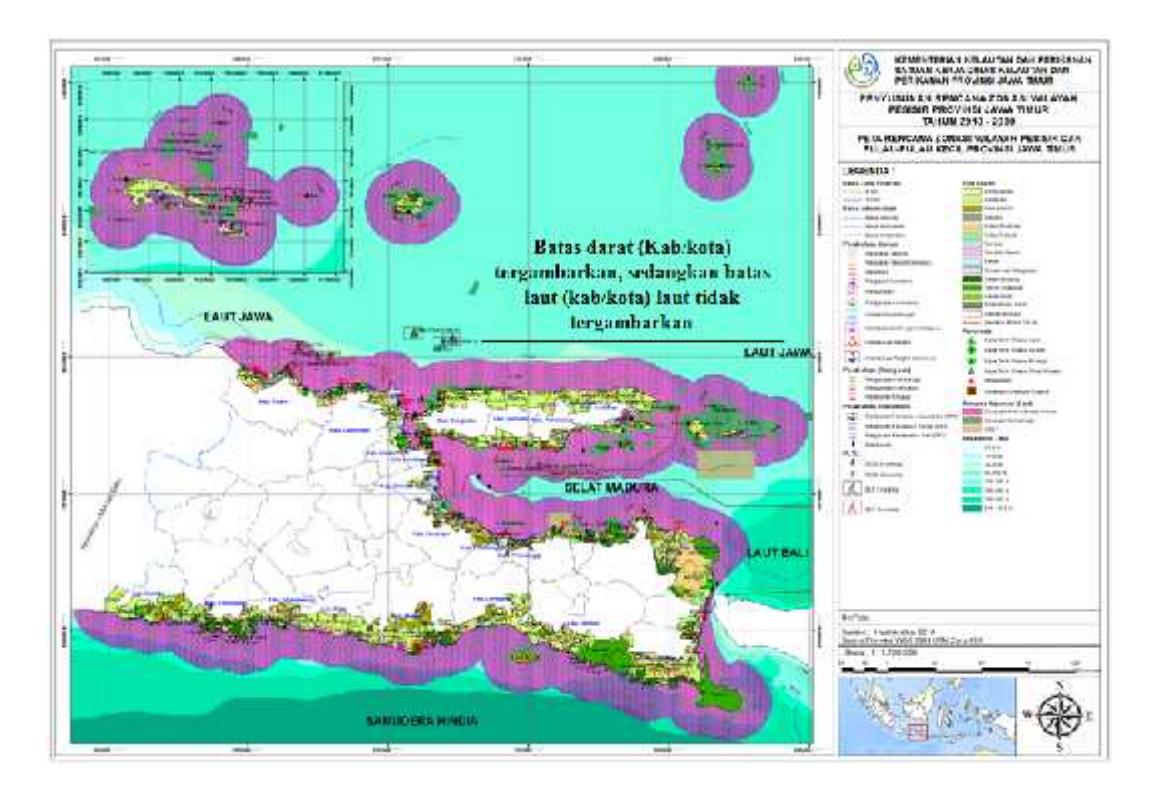
Picture1. Marine boundaries among districts in Madura Straits are still undecided on the map in Small Island of East Java Province in 2010-2030 (Ministry of Marine Affairs and Fishery and Office of Fishery and Ocean of East Java Province).
Picture 1 presents land administrative boundaries in provincial and district/city level, but it does not present the marine administrative boundaries in the region. In fact that marine boundary among local government territories is very important, especially in the area such as in Madura Straits where there are nine district government share marine border. The districts are Sumenep, Bondowoso, Pamekasan, Sampang, Bangkalan, Sidoarjo, Pasuruan, Probolinggo, Situbondo, and three cities as follows: Surabaya, Pasuruan, and Probolinggo. And in Indonesia have 324 of 497 local government are autonomy government (Ministry of Affairs, 2010).
It's implications if the marine boundary is not clear that it caused overlapping claims marine areas will lead marine border disputes conflict between provinces, between provinces and county/city and inter-county/city, such as the problem of DIY marine boundary between province of Central Java, determination marine boundary Pasuruan between Bangkalan, or Block Maleo grabs problem that the government of East Java Province with local government Sumenep related to oil and gas exploration results which potentially cause destruction and pollution in coastal and marine areas.
Every Indonesian coast have different characteristics from one another so that different ways to manage the coastal areas. That iswhy policies and institutional instruments formulated were not the same. This course will also influential in providing data and information on the management of coastal and marine areas in each region will be different(diverse).
2. Sectoral Management of Coastal and Marine Areas
Laws and regulations shows that marine of Indonesia managed by many ministries (at least 12 sectors), this fact can be determined based on the type and number of regulations issued by the Indonesian government over the years related to the implementation of marine management activities undertaken by each sector, has not been associated with provincial government regulations, city/ county. This condition often leads to national marine resources are managed by partial (based on sector legislation), each stand-alone (not integrated) and unfocused (managed without planning together). The impacts of the above conditions are vulnerable marine resource management conflicts between sectors and among regions.
Indonesia's marine and coastal areas are constitutionally managed by the Ministry of Marine Affairs and Fisheries. However, there is still unclear definition about how central and local government conducts coordination, share authority, and responsibility among them. What happens then is overlapping and conflicting jurisdiction. There are many interests that cannot easily accommodate. There might be synchronization among the government in planning level. But when it comes to economic and cultural sector, this synchronization is dismissed.
Some examples of sectoral legislation that is not related to the implementation of integrated marine use:
- 1. Licensing the use of the Ministry of Maritime and Fisheries Affairs and the Ministry of Forestry in the management of marine protected areas. Ministry of Forestry refers to Law No. 5 1960 about Conservation of Natural Resources and Ecosystems, and the Law No.41 1999 about Forestry. Ministry of Maritime and Fisheries Affairs refers to Law No.31 2004 about Fisheries and the Law No.27 of 2007 about Management of Coastal Areas and Small Islands.
- 2. Pollution cases: (a) by PT. Newmont Minahasa Raya in Buyat Bay. This case showed no relation between the Law No.11 1967 about Mining and Law No.23 1997 about Environment. (b) leakage of PERTAMINA's oil/gas pipeline. This case shows no relation between the Law No.9 1985 about Fisheries and Law No. 22 2001 about Oil and Gas.
- 3. Case Citanduy sodetan plan. This case shows no relation between Law No.22 1999 about Regional Government and Law No.41 1999 about Forestry.
- 4. Revocation of Article 1(18),16, 17, 18, 19, 20, 21, 22, 23 (4) and (5), 50, 51, 60 (1), 71 and 75. Whole articles related Hak Pengusahaan Perairan Pesisir (HP3/Rights to Conduct Business in Coastal areas) in the Law No.27 2007 declared invalid by the decision of the Constitutional Court No. 3 / PUU-VIII / 2010 because contradiction with the Constitution of the Republic Indonesia (UUD 1945) and do not have binding strength.
- 5. Besides managed by local government, national marine resource also managed by sector. Provisions of the 1945 Constitution juncto Article 33 Paragraph (33) UUPA juncto UNCLOS juncto Law 17 1985, marine can be partitioned in a parcel for exploitation and utilization, for example economical business space such as fish farming, seaweed, shellfish, seabed mining, as a space marine reserves and national parks, tourism and recreation, and public spaces such as ocean shipping lanes, ports and so on (Rais, 2002).Each sector (marine fisheries,
3. Customary Marine Tenure Problem
Different conditions and problems in western Indonesia, implementation of marine management in eastern Indonesia more often confronted with existence of customary marine management and emergence of problems between indigenous and local governments. There are 10,640 of 69 249 villages in Indonesia (over 14%) is a coastal village with an area 35,949,021.30 ha or 19% of total villages area in Indonesia. Approximately 92% of coastal villages in eastern Indonesia are traditional village who practice natural resource management based on local culture (Grand Design Rural Development, 2009). The problem is customary marine boundaries are determined based on customary laws prevailing in the region, as happened in Maluku province.
Maluku province has marine area 527.191 km2, land area 54.185 km2, and 559 islands (Maluku in Figures, 2011). Maluku province as the largest archipelago in Indonesian province discovered many indigenous villages existence that utilize archipelagic waters based on the local culture.
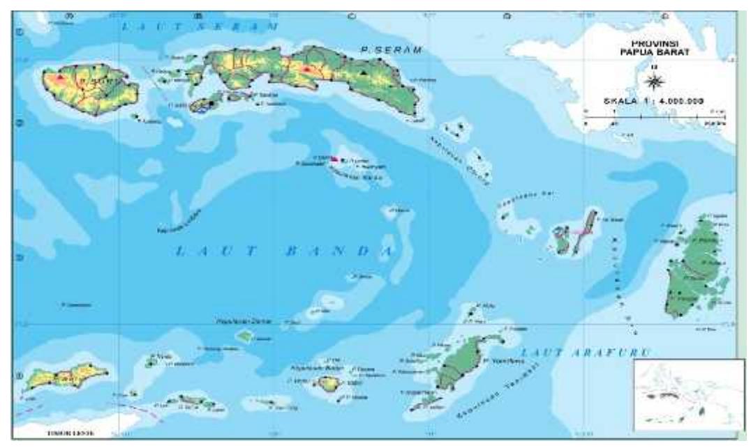
Figure 2. The geographical position of Maluku Province (BPK Maluku Province, 2003)
Maluku Province fisheries management practices based on local wisdom has long known as petuanan and sasi. Petuanan refers to exclusivity land area (petuanan darat) and marine area (petuanan laut), while sasi concept associated with customary rights that regulates system of exploitation existing resources in marine (petuanan laut). Generally sasi is legal provision about prohibition to enter, take or do something in a particular area within certain period (Wahyono, 2000).
Some villages in Maluku province that apply sasi for marine resource management:
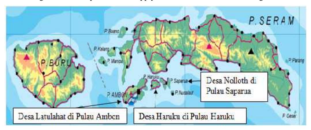
Figure 3. Some villages in Maluku province that apply sasi. (BPK Maluku Province, 2003)
Further explanation petuanan laut and sasi are follows:
1. Rights
Traditional village had autonomy to regulate traditional village property include communal land, forests and water. Rights of indigenous marine (customary rights) is a set of rules or marine area management systems based on custom (tradition) made by the people of coastal villages. These rules of customary rights over who has rights to an area, the type of resources that may be captured and techniques that allowed to exploit the resources that exist within a sea area.
2. Responsibilities
Sasi performed jointly by all the villagers, however, village government made conservation responsible team for monitoring sasi. Either public or conservation team that found violations, they report to village government. There is system of sanctions applicable and adhered by community, both local people and communities outside the village. Verdict sanctions in accordance with the level or type of violation committed. In addition sanctions process imposed gradually.
3. Restrictions
In Central Maluku (Nolloth and Haruku, Ambon Island, Latulahat) and Southeast Maluku (Kei), petuanan laut as well as petuanan darat have boundaries that are relatively clear. If boundary of petuanan darat between region one village to another village adjacent form natural boundaries (rivers, hills, headlands, caves) or artificial boundaries (intentionally planted trees, poles) then petuanan laut (marine) boundary between villages, country and retscaap is an imaginary line drawn from petuanan darat (land) boundary extends straight out to sea. Claim ownership of an inland sea areas (islands) are still being determined along sea boundary line. Marine boundary between petuanan laut and public property or common property is an imaginary line between the seas is shallow and the deep sea.
Figure 4. Petuanan laut boundary line based on imaginary and artificial boundary markers (Hernandi, et al, 2012).
Implications of customary marine delimitation induce boundaries conflict between traditional village (e.g. conflict Tutrean village with Sather village on Kei Besar island), village with outsiders (eg conflicts between Dian Village and Debut Village about license contract Oiwa Island to entrepreneurs pearl PT. Pear Nusantara in 1994), and customary marine border with local government marine authority boundaries. The problem of indigenous and local wisdoms cannot be avoided because the indigenous and local wisdoms are a part of Indonesian culture system.
2. Cadastre and Marine Cadastre Perspective
The term Cadastre is etymologically derived from the Greek katastikhon meaning public list showing details of ownership and value of land that was originally made for the purposes of taxation. The term of cadastre has existed in Indonesia introduced by the Dutch colonial government in 1823 with establishment Kadasterale Dienst (Cadastral Bureau) and the Japanese colonial period called Land Registry Bureau under Department of Justice, after the proclamation of independence later switched to Ministry of Home Affairs, and in1955 switch to Ministry of Agrarian, in 1966 changed to Directorate General of Agricultural Department of Home Affairs, then became a non-departmental government agency with the name National Land Agency. (Rais, 2002). After the enactment of Law No. 5 of 1960 on Basic Agrarian Law (UUPA), the term cadastre has been rarely used and more often use term Land Registry.
In Indonesia, data recording and information organized by land registration activity. Article 19 (1) UUPA notes to ensure legal certainty, government held land registration throughout the territory of the Republic of Indonesia in accordance with the provisions set forth by government regulations. Article 19 (2) the registration under subsection (1) of this article include:
- a. Measurement, mapping and land administration.
- b. Registration rights of land and transfer of such rights.
- c. Granting letters are valid proof of copyright as a strong verification tools. (Land Certificate).
International Federation of Surveyors (FIG) in 1995 defined Cadastre as follows:
A Cadastre is normally a parcel based, and up-to-date land information system containing a record of interests in land (e.g. rights, restrictions and responsibilities). It usually includes a geometric description of land parcels linked to other records
describing the nature of the interests, the ownership or control of those interests, and often the value of the parcel and its improvements.
Based on above definition, cadastre has 3 (three) main elements namely: right, restriction and responsibility. These three elements are interrelated, if it placed in land urgency can be made statement that right will be granted based on land uses in accordance with boundaries as measured and defined. Restriction is a jurisdictional boundary or limits the right of ownership relationship between people and land, can be interpreted that the right does not apply outside the limits owned. While the responsibility will always follow the right and restriction.
The three main elements of land cadastre can be approximated in physical form as Land Certificate. Land Certificate is a living archive that will not/never destroyed like other archives, it means always well maintained despite change in subject (land owner), changes in types of rights, and the imposition of changes in land stewardship obligations. It is therefore very different from the other certificate ownership and not as a product of community service. Literally, land certificate more functions as a control tool for management control, ownership, use and exploitation of land to the unconditioned sense of justice in the ownership and control of land use to prosperity and preserving environmental quality.
Indonesia as an archipelagic country has marine area larger than land area, 13.446 islands (Geospatial Information Agency, 2012) with coastline 99.093km (Geospatial Information Agency, 2013), making Indonesia has natural resources of the sea more than the natural resources on land. This potential condition of marine resources is seen as an opportunity for Indonesia as a developing country to build excellence in coastal and marine field.
Placement principle of land cadastral in the sea area is known and often referred as marine cadastre. Marine cadastre in simple terms can be regarded as the application of cadastre principles in marine area. In general, marine cadastre aims to administer marine space and marine resources including all interests, rights, restrictions and responsibilities that exist in the marine area. Marine cadastre concept lies in recording activities in the ocean by measuring the boundaries of the sea parcel. Sea parcel boundaries and identity depicted in a map large scale is accompanied by a note regarding right type, size, usage, value, insurance and other data, including restrictions on use.
Marine cadastre concept already used in some countries (non-islands) such as Australia, Canada and America. In Australia in 1999, Hoogsteden, Robertson, and Benwell formulate definitions marine cadastre as follows: marine cadastre is a system to enable the boundaries of maritime rights and interests to be recorded, spatially managed and physically defined in relationship to the boundaries of other neighboring or underlying rights and interests. Then in 2004 Anderw Binns defined marine cadastre is a spatial boundary management tool which describes, visualizes and realizes legally defined boundaries and associated rights, restrictions and responsibilities in the marine environment. Australian marine cadastre is used to achieve Australia's Marine Management System which was then used to regulate the activities of oil and gas sector, fisheries, aquaculture, shipping, conservation, marine heritage, cables and pipelines, coastal zone. Australian marine cadastre concept has been implemented in some states such as Queensland and Victoria.
In Canada in 2000 organized a Good Governance of Canada's Oceans to resolve the boundary problem as a first step to realize effective and fair marine management the effective management. Marine cadastre is defined by Nichols, Monahan and Sutherland as follows: a marine cadastre is a marine information system, encompassing both the nature and spatial extent of the interests and property rights, with respect to ownership and various rights and responsibilities in the marine jurisdiction.
In 2002 United States Department of Communication (U.S. DOC)-National Oceanic and Atmospheric Administration (NOAA) marine cadastre formulate definition: The U.S Marine Cadastre is an information system, encompassing both nature and spatial extent of interests in property, value and use of marine areas. Marine or maritime boundaries share a common element with their land-based counterparts in that, in order to map a boundary, one must adequately interpret the relevant law and its spatial context. Marine boundaries are delimited, not demarcated, and generally there is no physical evidence of the boundary.
How about Indonesia as the largest archipelago in the world? Marine cadastre in Indonesia is still a new concept, because Indonesia's development most priority in the land, whereas the sea area larger than the land area. However more research is concern in management coastal and marine spatial planning with the various aspects and approaches, but not much research concern with the cadastral elements: right, restriction and responsibility in the exploitation and utilization of ocean space.
Marine cadastre depend with how a state, especially Indonesia as an archipelagic state in manage and organize marine resources, so that marine cadastre problem in Indonesia as an archipelagic country will be different from marine cadastre problems in non archipelagic (continental) state. This condition causes the definitions of marine cadastre from continental states such as America, Canada and Australia cannot be fully implemented in Indonesia. Therefore it'll be needed marine cadastre definition for Indonesia that appropriate with the characteristics of Indonesia as an archipelagic state, then used it to build model concept and management of marine cadastre in Indonesia as an archipelagic state.
Previous research identified that conducting evaluation on definitions of marine cadastre in international level is very important. Later, this evaluation was continued by developing definitions of cadastre for marine issues in Indonesia as an archipelagic country. Therefore, the definition of cadastre in Indonesia is as follows: marine cadastre is a complex and dynamic operational system in managing coastal and marine resources by referring to area restrictions, authority rights and responsibility, that form integration among national administrative regions, provincial, and district/city with attention the existence of indigenous peoples, harmony and synergy between the central government and local governments (Astor, SULASDI, Hendriatiningsih, and Wisayantono, 2015).
3. The Model of Integrated Construction of Components in Marine Resources Utilization
The Model of integrated construction of components in marine resources utilization can be developed based on the following things:
- 1. Main principles of cadastre:right, restriction, responsibility.
- a. All marine utilization activities will have to define the rights and responsibility and conducted based on the predefined restrictions.
- b. Rights to explore and utilize marine resources must be based on type of activities, location of the exploration, marine space, the pattern of the exploration, and the length of the activities.
- c. Restriction is defined based on the territory of national, provincial, and district/city marine authority. Local people may define the map of restriction in their region which later will be authorized by local government.
- d. Responsibility is defined by referring to regulations determined by central, provincial, and local government and also by taking into account local wisdom in the region.
- 2. Five government regulation used as the basis for this research:
- a. Law Number 32 Year 2014 about Marine Affairs
The Law identifies Marine development as part of national development plan of Indonesia to become a strong, independent, developed, and welfare state according to Chapter 13 Verse 1 of the law:
- i. Management of marine resources
- ii. Human resource development
- iii. Defense, security, law enforcement, and marine safety.
- iv. Good governance and institution
- v. Welfare development
- vi. Marine based economic
- vii. Marine space management and protection
- viii. Marine culture
What is meant by marine management is all activities in fishery, energy and mineral resources, coastal and small island resources, non-conventional resources, marine industry, marine tourism, marine transportation, and marine buildings. The establishment of Marine Security Bureau (Bakamla) is intended to integrate authority for marine security; and inserting marine protection as an important component of all marine resources exploration activities.
b. Law Number 1 year 2014 about Management of Coastal areas and Small Islands.
This law is an amended version of the Law Number 27 year 2007. The most fundamental change in this law is that whoever wants to explore marine resources needs to have a Rights of Location and Rights of exploration as the policy replacing the previous Rights for Exploring Coastal Areas (HP3) which was enacted by Indonesian High Court of Constitution Number 3/PUU-VIII/2010 due to its opposite position with the national constitution of Indonesia (UUD 1945).
Rights to explore location must be obtained in order to have a space in coastal area and small islands to utilize their resources. Meanwhile, Rights to explore is awarded to those who want to utilize resources available in marine, coastal areas, and small island.
c. Law Number 23 year 2014 about Local Government
This law is an amended version of the law number 32 year 2004. In addition to providing guidelines for marine boundary determination among provinces and local government, the law also regulates share authority between central and local government, and also acknowledge the existence of indigenous people in remote areas. Indigenous people have the rights to submit their areas to be included in RZWP3K in national, provincial, and local level. Thus, information about restriction, rights and responsibility for the indigenous people are included in marine resources management in Indonesia. Therefore, a harmonized coordination in marine resource management among central, provincial, and local government can be realized.
d. The Law Number 4 year 2011 about Geospatial Information Integration system based on the Law Number 4 year 2011 about Geospatial Information consists of definition that geospatial information provider is a shared responsibility of central, provincial, and local government in which all government institutions need to collaborate to strengthen geospatial information and encourage the utilization of the information.
Synchronization can be achieved through one geospatial reference system that can be used to all marine exploration activities. What is meant by geospatial reference system is geodesies data, coordinate reference system, and projection system. Using similar geospatial reference system does not mean that all other system need to be combined. Chapter 34 (a) of the Law Number 4 year 2011 identifies that "a clear and well-defined Projection system and coordinate system can be transformed into national standardized coordinate system." This chapter consists of definition that different geospatial reference system is allowed but must refer to the national geospatial system.
Picture 5. Visualization of activities utilizing marine resources in sectoral system using different geospatial reference (Modified from Towards a Marine Cadastre, 2009)
Picture 6. Visualization of the transformation process from sectoral coordinate system to national coordinate system (Modified from Towards a Marine Cadastre, 2009)
Picture 7. Visualization of Integration Marine Utilization Activities in the system of national coordinate (Modified from Towards a Marine Cadastre, 2009)
In addition to implementing national geospatial reference system, in order to realize integration on marine and coastal management, Indonesia needs a regulation intended to standardize geospatial information that includes reference system, map projection system, boundaries, coastlines, map scales, and etc. Indonesian Coastline Environment Map (LPI) and Indonesian Marine Environmental Map (LLN) can be used as the basis for developing Indonesia Marine Cadastre Map. The use of marine cadastre map as the sole reference in the utilization of marine and coastal resources is expected to become basis for government in all levels to identify boundaries in utilizing the resources.
Locations and boundaries of the utilization of marine and coastal resources depicted in the Map of cadastre in Indonesia can be used as the basis for submitting proposal to have the rights and responsibilities to utilize the resources.
e. The regulation of the Ministry of Home Land affairs Number 76 year 2012 about the manual and guideline for region boundaries.
Operating regulation about region boundaries is enacted through The regulation of the Ministry of Home Land affairs Number 76 year 2012 about the manual and guideline for region boundaries. Although the Law about local government have been amended, the operating system of how to define local boundary is still referred to The regulation of the Ministry of Home Land affairs Number 76 year 2012.
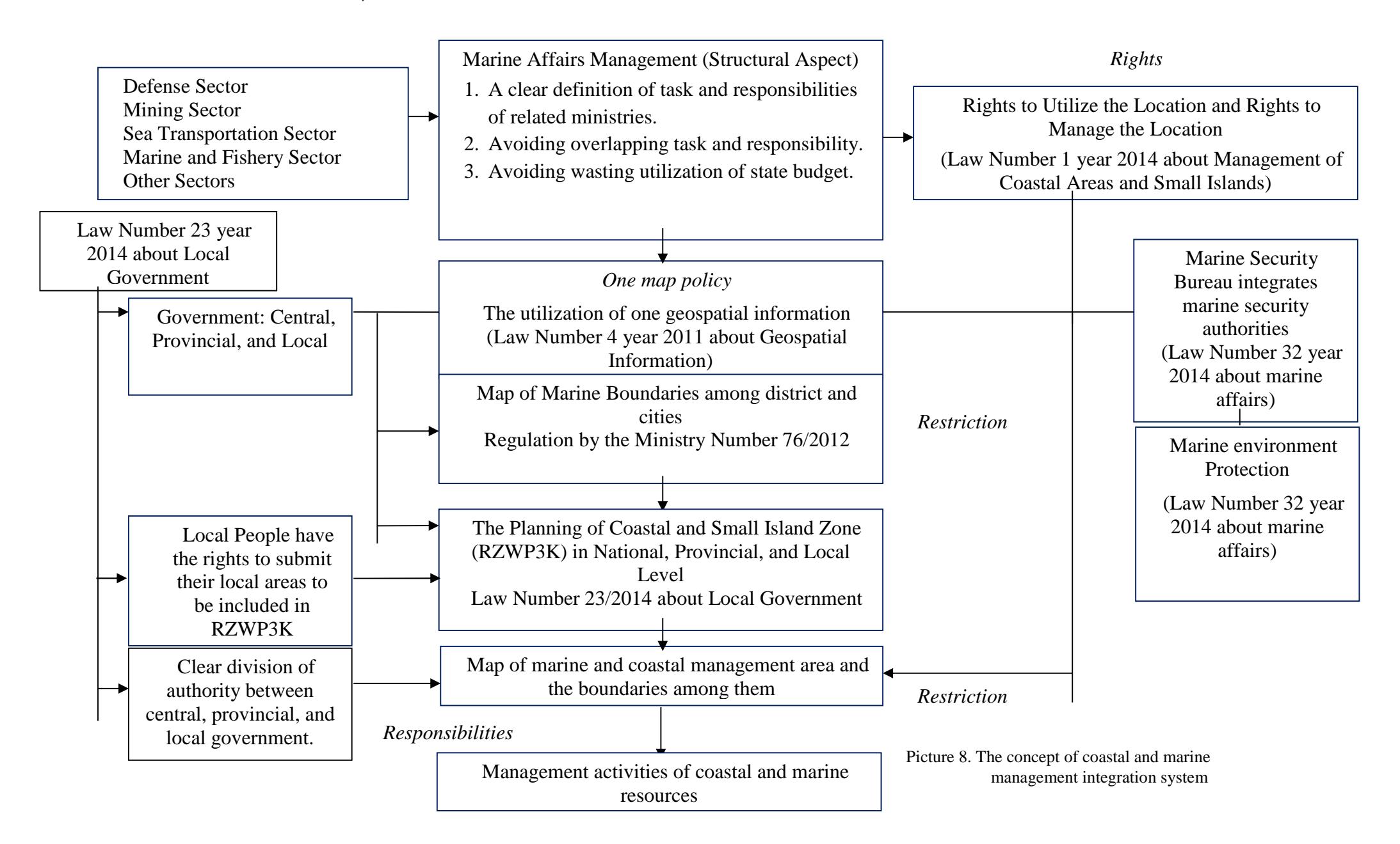
Picture 8 below presents the position and correlation of five regulations enacted to rule marine resources in Indonesia. The picture is an integrated concept about marine resources management in Indonesia.
4. Conclusions and Recommendations
a. Conclusions
- 1. From above discussion it can be concluded that the implementation of marine management in Indonesia is strongly influenced by the system of regional autonomy, sectoral and customary system.
- 2. Coastal and marine resources management must be conducted in integrated ways by involving all components and governmental level in Indonesia. Indonesia needs to redefine its regulations related marine and coastal resources management, develop one map policy to define marine boundaries among local government's areas, and apply a system intended to regulate permissions for utilizing and managing marine and coastal resources and to protect them.
b. Recommendations
1. Indonesia needs an integrated management system for its marine and coastal resources. The system must make clear authorities and rights of governmental level that share marine and coastal resources boundaries.